MyHazards
California Emergency Managment Agency
Use this website to discover the hazards that exist in your area and learn how to reduce your risk.
The Earthquake Country Alliance provides information and resources to help everyone who lives, works, or travels in earthquake country get prepared to survive and recover quickly, by following the Seven Steps to Earthquake Safety.
Fault maps, historic earthquakes, how the ground is expected to shake, and much more
California Geological Survey (CGS)
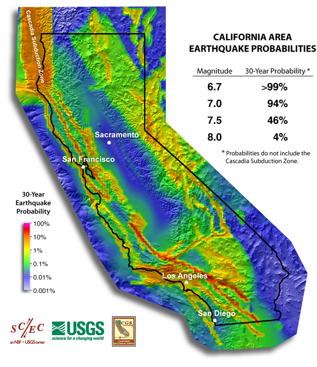
Forecast of California Earthquakes
Southern California Earthquake Center, USGS, and CGS
Earthquake Shaking Potential Map of California (Dec. 2008)
California Geological Survey (CGS)

Maps of recent earthquakes, ShakeMaps for larger earthquakes, email notification, and more
California Integrated Seismic Network
Earthquake and Tsunami Hazards and Mitigation Information
California Emergency Management Agency
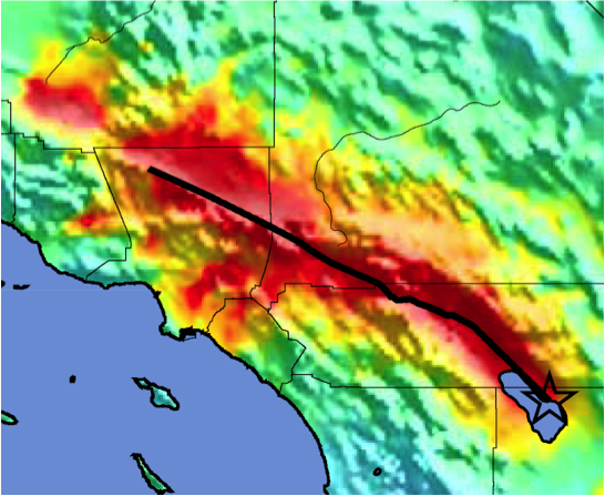
ShakeOut Scenario
This detailed analysis of a magnitude 7.8 earthquake along the southern San Andreas fault was produced in 2008 as the basis of the Golden Guardian exercise and first-even ShakeOut earthquake drill, and is a product of the United States Geological Survey, Multi-Hazard Demonstration Project, led by Dr. Lucy Jones.
Putting Down Roots in Earthquake Country, Living on Shaky Ground, and similar publications
These booklets for Southern California, the Bay Area, and the North Coast each provide an overview of earthquake hazards in their region, earthquake science basic information, and feature the Seven Steps to Earthquake Safety.
Resources from FEMA: