
“IT’S HOT AND DRY — EARTHQUAKE WEATHER!”
Many people believe that earthquakes are more common in certain kinds of weather. In fact, no correlation with weather has been found. Earthquakes begin many kilometers below the region affected by surface weather. People tend to notice earthquakes that fit the pattern and forget the ones that don’t. Also, every region of the world has a story about earthquake weather, but the type of weather is whatever they had for their most memorable earthquake.
Earthquakes are recorded by a seismic network. Each seismic station in the network measures the movement of the ground at that site. In an earthquake, the slip of a block of rock over another releases energy that makes the ground vibrate. That vibration pushes the adjoining piece of ground, causing it to vibrate, and thus the energy travels out from the earthquake in a wave. As the wave passes by a seismic station, that piece of ground vibrates and this vibration is recorded.
Earthquakes produce two main types of waves – the P-wave (a compressional wave), and the S-wave (a shear wave). The S-wave is slower but larger than the P-wave and does most of the damage. Scientists have used knowledge of the differences between these and other seismic waves to learn a great deal about the interior of the earth.
Knowing how fast seismic waves travel through the earth, seismologists can calculate the time when the earthquake occurred and its location by comparing the times when shaking was recorded at several stations. This process used to take almost an hour when done manually. Now computers determine this information automatically within minutes. Within a few more hours the shape and location of the entire portion of the fault that moved can be calculated.
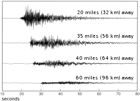
These seismograms show how the ground moved at four seismic stations during an earthquake. The time when the ground starts shaking is the arrival of the P-wave. The ground starts shaking sooner and shakes more at sites nearer the earthquake.
We name earthquakes after map locations near epicenters to have a convenient way to refer to them, but this can be misleading. We define the epicenter of an earthquake with the latitude and longitude of a point, but the earthquake is bigger than that point. The fault’s rupture surface can be hundreds of kilometers long and several kilometers wide, and even the epicenter can only be determined within a few tenths of a kilometer. Therefore, giving the location of an earthquake in terms of city streets is like giving the location of your city by the address of City Hall.
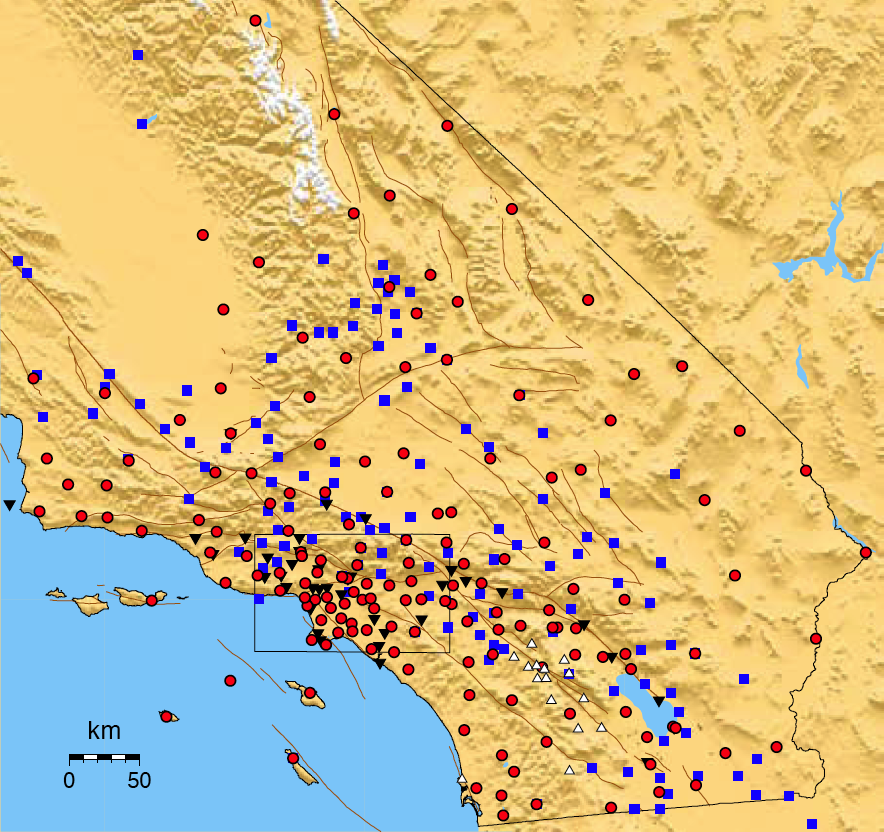
Larger imageThe Southern California Seismic Network (SCSN) records data from more than 370 seismic stations. Each station records seismic waves from both near and distant earthquakes. All the data are transmitted automatically to Caltech/USGS in Pasadena for processing and distribution of information such as epicenters, magnitudes, and ShakeMaps. The SCSN is also part of the California Integrated Seismic Network (CISN) that coordinates earthquake monitoring statewide. The symbols indicate different types of seismic stations.
How big was the earthquake?
Why do scientists have problems coming up with a simple answer to this simple question? Many people have felt this frustration after earthquakes, as seismologists often seem to contradict one another. In fact, earthquakes are very complex. Measuring their size is something like trying to determine the “size” of an abstract modern sculpture with only one use of a tape measure. Which dimension do you measure?
Magnitude is the most common way of describing an earthquake’s size. In the 1930’s, Beno Gutenberg and Charles Richter at the California Institute of Technology developed a method to describe all sizes of earthquakes using a small range of numbers. Using recordings from seismographs, they measured how fast the ground moved at a set distance from earthquakes. If the maximum acceleration of the ground in one earthquake is 10 times the maximum acceleration in another earthquake, then the first earthquake is said to be one unit of magnitude larger than the second. The Richter Scale, as it became known, is not a device, but the range of numbers used to compare earthquakes.
Seismologists have since developed a new measurement of earthquake size, called moment magnitude. Moment is a physical quantity more closely related to the total energy released in the earthquake than the Richter magnitude. It can be estimated by geologists examining the geometry of a fault in the field or by seismologists analyzing a seismogram. Because the units of moment are very large, it has been converted to the more familiar range of magnitude values for communication to the public.
Moment magnitude has many advantages over other magnitude scales. First, all earthquakes can be compared on the same scale. (Richter magnitude is only precise for earthquakes of a certain size and distance from a seismometer.) Second, because it can be determined either instrumentally or from geology, it can be used to measure old earthquakes and compare them to instrumentally recorded earthquakes. Third, by estimating how large a section of fault will likely move in the future, the magnitude of that earthquake can be calculated with confidence.
Who monitors California’s earthquakes?
Earthquake monitoring for California is done by the California Integrated Seismic Network (CISN), a partnership among the U.S. Geological Survey (USGS), University of California Berkeley, Caltech, the California Geological Survey, and the Governor’s Office of Emergency Services. CISN is part of a USGS national seismic monitoring program called the Advanced National Seismic System (ANSS). For more information go to www.cisn.org/ or www.anss.org/.
| Magnitude | Date | Location | Rupture Length (kilometers) |
Duration (seconds) |
|---|---|---|---|---|
| 9.1 | December 26, 2004 | Sumatra, Indonesia | 1200 | 500 |
| 7.9 | January 9, 1857 | Fort Tejon, CA | 360 | 130 |
| 7.9 | May 12, 2008 | Sichuan, China | 300 | 120 |
| 7.8 | April 18, 1906 | San Francisco, CA | 400 | 110 |
| 7.3 | June 28, 1992 | Landers, CA | 70 | 24 |
| 7.3 | August 17, 1959 | Hebgen Lake, MT | 44 | 12 |
| 7.0 | October 17, 1989 | Loma Prieta, CA | 40 | 7 |
| 7.0 | October 28, 1983 | Borah Peak, ID | 34 | 9 |
| 6.8 | February 28, 2001 | Nisqually, WA | 20 | 6 |
| 6.7 | January 17, 1994 | Northridge, CA | 14 | 7 |
| 6.4 | March 10, 1933 | Long Beach, CA | 15 | 5 |
| 5.9 | October 1, 1987 | Whittier Narrows, CA | 6 | 3 |
| 5.4 | July 29, 2008 | Chino Hills, CA | 5 | 1 |