Magnitude is a measurement of the energy produced by an earthquake and is not a measure of the shaking you feel. What you feel is very complex – hard or gentle, long or short, jerky or rolling – and is not describable with one number. What you feel in an earthquake is controlled by three main factors: magnitude, distance, and local soil conditions.
Magnitude
Typically you will feel more intense shaking from a big earthquake than from a small one. Bigger earthquakes also release their energy over a larger area and for a longer period of time.
An earthquake begins at a hypocenter, and from there the rupture front travels along the fault, producing waves all the time it is moving. Every point crossed by the rupture front gives off shaking, so longer faults produce bigger earthquakes that have longer durations. The actual durations of 15 earthquakes are shown here. For a magnitude 5 event, the actual process of rupturing the fault is over in a few seconds, although you might continue to feel shaking for longer because some waves reach you after they bounce and echo within the earth.
The magnitude 7.8 earthquake on the San Andreas fault in 1857 ruptured almost 360 kilometers (220 miles) of the fault. At 3 kilometers (2 miles) per second, it took two minutes for that length of fault to rupture, so you would have felt shaking for several minutes.

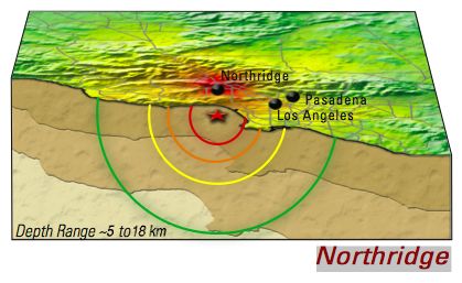
Larger imageThe 2001 Nisqually (M6.8) and 1994 Northridge (M6.7) earthquakes shown above provide an interesting example of how distance from an earthquake affects the level of shaking experienced. Even though the Nisqually earthquake was slightly larger than the Northridge earthquake on the magnitude scale, the resulting damage was far less. One reason is that the section of fault that moved was much deeper than the fault that moved in the Northridge earthquake. Therefore every house was at least 50 kilometers (30 miles) away from the fault.
Distance
Earthquake waves diminish in intensity as they travel through the ground, so earthquake shaking is less intense farther from the fault.
Low-frequency waves diminish less rapidly with distance than do high-frequency waves. If you are near an earthquake, you will experience all the shaking produced by the earthquake and feel “jolted.” Farther away, the higher frequencies will have died away and you will feel a rolling motion.

The amount of damage to a building does not depend solely on how hard it is shaken. In general, smaller buildings such as houses are damaged more by higher frequencies, so usually houses must be relatively close to the hypocenter to be severely damaged. Larger structures such as high-rises and bridges are damaged more by lower frequencies and will be more noticeably affected by the largest earthquakes, even at considerable distances.
Local soil conditions
Soils can greatly amplify the shaking in an earthquake. Passing from rock to soil, seismic waves slow down but get bigger. Hence a soft, loose soil may shake more intensely than hard rock at the same distance from the same earthquake. An extreme example for this type of amplification was in the Marina district of San Francisco during the 1989 Loma Prieta earthquake. That earthquake was 100 kilometers (60 miles) from San Francisco, and most of the Bay Area escaped serious damage. However, some sites on landfill or soft soils experienced significant shaking.
The same factors also apply to areas covered by thick sediment – such as the Los Angeles basin in where sediments can be as much as 10 kilometers (6 miles) thick. Shaking from an earthquake in the region can be 5 or more times greater at a site in the basin than the level of shaking in the nearby mountains.
P.S.
Several other factors can affect shaking. Earthquake waves do not travel evenly in all directions from the rupture surface; the orientation of the fault and the direction of movement can change the characteristics of the waves in different directions. When the earthquake rupture moves along the fault, it focuses energy in the direction it is moving so that a location in that direction will receive more shaking than a site at the same distance from the fault but in the opposite direction. This is called directivity.
Online Earthquake Information
After an earthquake, knowing more about what just happened can reduce fear and help you understand what to expect next. Online earthquake information products include:
Recent earthquakes map – Within 1 to 2 minutes of an earthquake, its location and magnitude are available at several Web sites, including https://scedc.caltech.edu and earthquakes.usgs.gov.
“Did You Feel It?” – Tell us what you felt! Personal experiences of the effects of an earthquake are very valuable to scientists. When you have felt a quake, please report your observations by using a quick survey found on the U.S. Geological Survey “Did You Feel It?” Web site at https://earthquake.usgs.gov/data/dyfi/.
When you fill out this online survey, your observations of actual damage and shaking are combined with those of thousands of other people. The quake’s shaking intensities, derived from these observations, are displayed by ZIP code on a “Community Internet Intensity Map.”
“ShakeMap” – Within 5 to 10 minutes of most felt earthquakes (magnitude 3.5 and greater) in Southern California, a “ShakeMap” is posted on the Web. This map shows the range of shaking intensities across a region. Every quake has only a single magnitude, but it produces a range of shaking intensity values over the area in which it is felt.
ShakeMaps use data from seismic instruments to provide a rapid picture of where the strongest shaking occurred. These maps help to identify areas where a quake’s impact is greatest and are used by emergency managers to speed disaster response. ShakeMaps are available at www.cisn.org/shakemap.html or https://earthquake.usgs.gov/data/shakemap/.